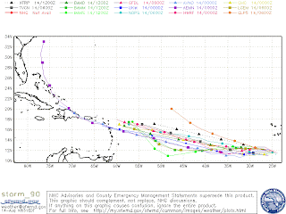
Picture Credit: Hardcore WeatherI
t is just a matter of time before invest 90L will become a tropical storm. Data and satellite images indicate that invest 90L is already a tropical depression, but its center is still exposed. Until that center closes completely, no classification will be official. On that note, I believe that invest 90L will become a tropical storm by Sunday the latest and a hurricane by Tuesday. It is kind of hard to make these predictions since it is not even a storm yet, but this wave has the potential to do so once it gets its act together. Models have consistently, for now, been indicating that invest 90L will be a hurricane off the Southern Bahamas in 8 days (August 22).
NOTHING is for sure, but we do have to follow and track this wave. Computer models are developing the wave and it hasn't even become a storm yet. Like I have said, once the wave develops and the computer models get a better hold of the wave, then let's see what they have to say. For now, have been very consistent with landfall being anywhere from Louisiana to NorthCarolina. I have seen model runs that make landfall anywhere in between. The only thing that is consistent, but not guaranteed, is landfall in this area. I will try and send updates throughout the weekend if anything important arises. Attached are spaghetti models as of today. It is kind of impressive how the models are so tightly clustered all the way thru 7-8 days away AND not even developed. Let see what happens throughout the weekend.
Friday, August 14, 2009
Subscribe to:
Post Comments (Atom)


No comments:
Post a Comment